Frystown Fifty
I've got this long race coming up June 2nd, so I've got some training to do. Coming off the 12 Hours of Lodi, I made it an easy week with mostly commuting. All that changed Saturday. I got up, did some dishes, then set up a route to ride to my friend Bill's house in Frystown. It literally went like that. I made the route, entered it in my GPS and took off on the fixie.
 I think I was twenty miles in when I realized I made a mistake. The route there was supposed to be roughly fifty miles. That meant a hundred miles round trip. That's a hundred miles with hills. I hadn't done that before on the fixie, but I was pretty sure it was a bad idea at this point.
Quickly I came up with a plan. I'd start counting or paying attention to the hills I couldn't pedal down. I figured if I couldn't pedal my way down it, there was no way I could pedal up it. If the number of "no way ups" or "too long to walk" hills got ridiculous, I'd have to come up with an alternate route home.
I lost track. There were too many turns, too much traffic, and too much sun. I plowed on.
If you're ever going north or north west from my area, you have to climb a ridge before you get to the valley before the Blue mt. ridge. I'm not sure what the name of this first ridge is (it's too late to figure it out), but it's related to the ridge in Valley Forge. It practically runs parallel to the turnpike till it hits Harrisburg and the Blue Mt. ridge. I hit this unnamed ridge on Texter Mt. road. I knew from my GPS data, I'd climb about five hundred feet in a short stretch. What I didn't know was it would be in the form of a dozen or so short steeps separated by false flats for a mile or so. It sucked. I climbed, wheezed, got dizzy, nearly blacked out and fell over before I passed a guy that said "you're almost there." With one final push I made it and turned left to go down. At the top was this.
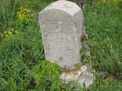 Why is the county marker a tombstone? Actually, this marked the death of my ride. At this point I turned left on S. Mountain Rd and went downhill for a long time. I went down longer then it took me to come up. I went down with the brake on nearly the entire time. I wasn't coming back that way. When I hit 422, I decided I'd had enough. I was two and a half hours in, I had to get back. I flipped through the screens on my GPS and noticed I was at mile 40. That was just 10 miles short of Bill's. What the hell? Why come all this way and not finish it? I turned back and headed for Bill's.
It wasn't long before I saw this.
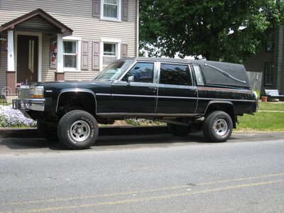 That's when I knew I made the right choice. I call it the "Hillbilly Hearse." Pretty original huh?
Soon after the hearse, I got to Bill's. I raided their fridge for some cold chicken, an old Coke and Gatorade. Saw the new pool, congratulated Bill on finally graduating from his Actuary hell and rolled on with a different return route. I decided to shoot for flat. From Bill's, that meant a lot of roads with traffic. Basically I'd hit 419 s. to 422 e. to 724 e. to 82 s. Ugly roads I know, but relatively flat. At some point I realized it didn't make a difference if I could hear the cars coming behind me and cranked up the iPod. Soon I was cruising singing out loud and feeling good. There may have even been some shoulder shaking, but I'm not going to admit to that.
Just outside of Birdsboro at mile 86, I stopped for food and phone calls. My car was in the shop, so I had to take care of the bill. I called Jen and let her know where I was. I apologized for being way late and leaving her home to work all day.
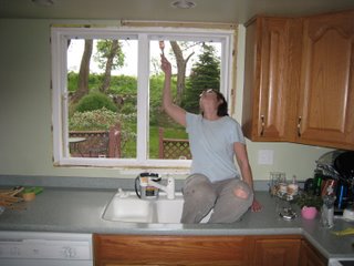 I really felt awful, but the windows look great! I told her I had only one main road to go and it should take around two hours. Not quite.
On rt. 82 below Birdsboro, the bridge is out. I thought I remembered it being "out" for car travel, but pedestrians and cyclists were fine. I was wrong.
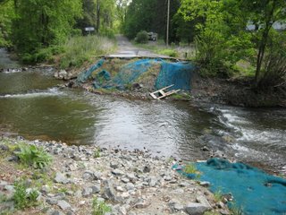
Off with the socks and shoes and through the water. As I'm riding on the other side, I notice the road is rather crappy. It's plain coming apart, then my fears are confirmed.
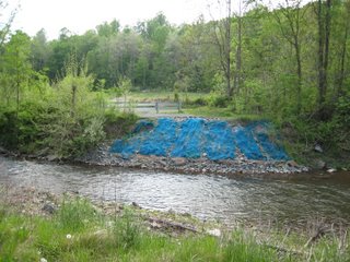 Two bridges out! What's worse, I've been here before and don't remember the bridges being completely out. Anyway, clean up the feet, throw on the socks and shoes and roll. The end was pretty anti-climactic. The last twenty miles hurt a lot. I just wanted it over. I rolled in with almost 115 miles.
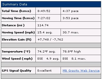
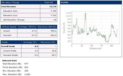
Here's the data for those interested:
I think I was twenty miles in when I realized I made a mistake. The route there was supposed to be roughly fifty miles. That meant a hundred miles round trip. That's a hundred miles with hills. I hadn't done that before on the fixie, but I was pretty sure it was a bad idea at this point.Quickly I came up with a plan. I'd start counting or paying attention to the hills I couldn't pedal down. I figured if I couldn't pedal my way down it, there was no way I could pedal up it. If the number of "no way ups" or "too long to walk" hills got ridiculous, I'd have to come up with an alternate route home.
I lost track. There were too many turns, too much traffic, and too much sun. I plowed on.
If you're ever going north or north west from my area, you have to climb a ridge before you get to the valley before the Blue mt. ridge. I'm not sure what the name of this first ridge is (it's too late to figure it out), but it's related to the ridge in Valley Forge. It practically runs parallel to the turnpike till it hits Harrisburg and the Blue Mt. ridge. I hit this unnamed ridge on Texter Mt. road. I knew from my GPS data, I'd climb about five hundred feet in a short stretch. What I didn't know was it would be in the form of a dozen or so short steeps separated by false flats for a mile or so. It sucked. I climbed, wheezed, got dizzy, nearly blacked out and fell over before I passed a guy that said "you're almost there." With one final push I made it and turned left to go down. At the top was this.
Why is the county marker a tombstone? Actually, this marked the death of my ride. At this point I turned left on S. Mountain Rd and went downhill for a long time. I went down longer then it took me to come up. I went down with the brake on nearly the entire time. I wasn't coming back that way. When I hit 422, I decided I'd had enough. I was two and a half hours in, I had to get back. I flipped through the screens on my GPS and noticed I was at mile 40. That was just 10 miles short of Bill's. What the hell? Why come all this way and not finish it? I turned back and headed for Bill's.It wasn't long before I saw this.
That's when I knew I made the right choice. I call it the "Hillbilly Hearse." Pretty original huh?Soon after the hearse, I got to Bill's. I raided their fridge for some cold chicken, an old Coke and Gatorade. Saw the new pool, congratulated Bill on finally graduating from his Actuary hell and rolled on with a different return route. I decided to shoot for flat. From Bill's, that meant a lot of roads with traffic. Basically I'd hit 419 s. to 422 e. to 724 e. to 82 s. Ugly roads I know, but relatively flat. At some point I realized it didn't make a difference if I could hear the cars coming behind me and cranked up the iPod. Soon I was cruising singing out loud and feeling good. There may have even been some shoulder shaking, but I'm not going to admit to that.
Just outside of Birdsboro at mile 86, I stopped for food and phone calls. My car was in the shop, so I had to take care of the bill. I called Jen and let her know where I was. I apologized for being way late and leaving her home to work all day.
I really felt awful, but the windows look great! I told her I had only one main road to go and it should take around two hours. Not quite.On rt. 82 below Birdsboro, the bridge is out. I thought I remembered it being "out" for car travel, but pedestrians and cyclists were fine. I was wrong.
Off with the socks and shoes and through the water. As I'm riding on the other side, I notice the road is rather crappy. It's plain coming apart, then my fears are confirmed.
Two bridges out! What's worse, I've been here before and don't remember the bridges being completely out. Anyway, clean up the feet, throw on the socks and shoes and roll. The end was pretty anti-climactic. The last twenty miles hurt a lot. I just wanted it over. I rolled in with almost 115 miles.Here's the data for those interested:
posted by JenBob at
11:49 PM
![]()
1 Comments:
You hit some good hills around the Wernersville/Robesonia area. I loop out that way from my place. 422 and 724 suck, 82's been washed out for years, I waded it too the first time through there.
Post a Comment
<< Home